The extent to which groundwater can replenish itself in a location, and the amount of groundwater levels that can develop, are both factors that depend on a variety of influencing variables. Some of these variables include the distance between the aquifer from the top of the ground surface, the characteristics of the upper layers above the aquifer, the size and shape of rock cavities and the subterranean in- and outflow of groundwater as well as the volume of abstractions. Above all, it must be remembered that the groundwater formation in a given location is dependent on precipitation and surface discharge as well as evaporation. If the climatic conditions change, this will affect the formation of groundwater.
Rising temperatures act as triggers for a potentially higher evaporation overall, which means that less water will seep away for infiltrating the groundwater. Years with lower total precipitation do not immediately affect groundwater levels. This is because – in comparison with surface water – groundwater tends to respond relatively slowly to a changed precipitation regime. However, the situation can escalate when the availability of water is restricted long-term by the precipitation diminishing combined with higher evaporation. Both, changes in temperatures and in precipitation, affect the surface discharge, with knock-on effects on the groundwater. If precipitation occurs predominantly in winter, falling on soils saturated with water or possibly on soils that are frozen hard, its ability to seep away is restricted. By contrast in summer soils dry out more strongly and can hardly or not at all absorb precipitation, especially as it falls more frequently as heavy rain. The continuing encroachment of sealed surfaces (cf. Indicator RO-R-5) and insufficient variety of structures in intensively farmed areas exacerbate the problem of the reduced replenishment of groundwater resources.
In order to obtain an overview of the development of groundwater levels in Germany, 148 groundwater gauging stations and spring flow points were selected in order to generate two indicators for the majority of the larger Länder (except for Saarland) and hydrogeological environments, for which mostly consistent data are available from 1971 onwards; in respect of 117 gauging stations the observation series even date back as far as 1961. All these gauging stations are in the uppermost aquifers and they are, as far as possible, unaffected by anthropogenic influences. In other words, there is no groundwater abstraction or irrigation taking place in the catchment area, the density of sealed surfaces is low, and during the period of observation there have been few changes in land management in the area. This makes it possible to a considerable extent, to make connections between any changes observed at these gauging stations and changes in the temperature and precipitation regimes.
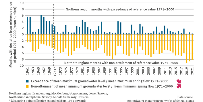
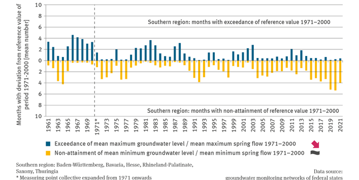
Given the different natural areas and climatic conditions within Germany, the indicator differentiates between the northern and southern parts of the country. The illustration shows the mean number of months – distributed across all gauging stations – in which the monthly mean of groundwater levels or spring flows was lower than the mean of the lowest groundwater levels or spring flows calculated for the relevant gauging stations during the years of 1971 to 2000. The same approach was adopted for comparing the monthly mean of groundwater levels or spring flows with the long-term highest groundwater levels or spring flows.
Trends indicating a falling number of months in which the long-term highest groundwater levels or spring flows are exceeded as well as trends indicating a rising number of months in which the long-term lowest groundwater levels or spring flows are not attained, are more prominent in the north than in the south, and they are statistically significant. In the south, only the decreasing cases of exceedance are significant. However, both regions witnessed record low-water levels from 2019 onwards resulting from the extremely dry years of 2018 to 2019. There are several gauging stations where – from 2019 onwards – the monthly mean of groundwater levels or spring flows was – almost throughout the relevant year – below the long-term lowest groundwater levels or spring flows.
In Germany almost three quarters of drinking water is abstracted from groundwater. The formation of adequate replenishment of groundwater is therefore an essential prerequisite for both – a sustainable supply of drinking water, and for supplying ecosystems with sufficient water.

