Progressive climate change is apt to change the frequency and severity of flood events and inundations, for instance when heavy rain events in summer become more frequent and more intensive, or when winter precipitation increases or falls more often as rain (cf. Indicators WW-I-4, WW-I-5 and BAU-I-4). In cases where soils are already saturated with water or severely desiccated, or there is a lot of precipitation in a very short time, not much of this will be able to infiltrate the soil. As a rule, this precipitation will run off the surface draining directly into water courses. Consequently, provident flood control is an important measure for the adaptation to impacts of climate change (cf. Indicators WW-R-2, and WW-R-3).
The designation of flood plains therefore is a key component of preventive flood control, as per mandatory regulations laid down in the Water Resources Act (WHG), to be observed nationwide. It is the remit of competent authorities to designate flood plains within areas perceived to be at risk thus ensuring that they are available for flooding in case of a so-called 100-year flood event. Furthermore, areas such as flood polders and flood channels have to be included in this designation to serve as flood relief spillways.
However, over and above any legal water-related regulations, it is the remit of spatial planning to use its own tools for contributing to preventive flood control. An essential element of the planning toolbox available for this purpose is the use of spatial planning specifications on flood control. These can be used to govern land use in a way that makes an area less vulnerable to flood risks given that such risks are expected to increase as a result of climate change. In endangered areas, it is possible – beyond the requirements of water-related legislation for floodplains – to preclude the utilisation of these areas for settlement or infrastructure purposes. Areas of importance for water retention in the landscape and for provident flood control with a view to climate change, can be safeguarded or protected by means of imposing usage restrictions.
The most significant spatial planning tool for this purpose is the designation of priority areas for preventive flood control. In any such areas, flood protection takes priority over any other utilisation of space or spatial functionalities. Any types of spatial utilisation incompatible with this objective are precluded in this area. So far the practice of designating priority areas has been generally heterogeneous among planning regions. However, it is typically based on the demarcation of recognised flood plains in line with water-related legislation. In some cases, specifications are included in regional plans as memoranda, in others the designated priority areas are identical with specified flood plains, while in some other regions priority areas extend beyond the demarcation of flood plains.
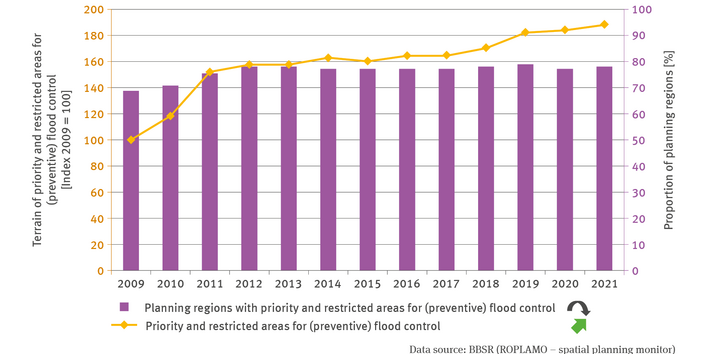
As decreed in the WHG, the designation of flood plains was supposed to be finalised by the end of 2013. As was to be expected, however, numerous planning regions have had to postpone any first-time or renewed designation of priority and restricted areas reserved for preventive flood control to a later date, and in some planning regions this transition still remains to be completed. By 2021, the overall terrain designated as priority and restricted areas in planning regions employing regional planning comprised a total of approximately 13,500 square kilometres. While the number of designating planning regions remained virtually constant over the past 10 years, there has been a continued increase in the nationwide designation of terrain reserved for flood control, largely due to updates and newly drawn up regional plans. Overall, the extent of designated terrain has experienced an increased since 2009 by 6,300 square kilometres.
In the interest of the adaptation to impacts of climate change and in order to enhance risk provisioning for extreme flooding events, it seems desirable – where appropriate – to strengthen spatial planning designations for preventive flood control by going beyond the legal specification of flood plains. In past years, various modelling projects with regard to spatial planning were used to explore what possibilities exist for risk provisioning also in those areas which, strictly speaking, are already protected from floodwater by dykes. In the region of Oberes Elbtal-Osterzgebirge, for example, a new methodology was developed for designating priority and restricted areas for preventive flood protection and this methodology was implemented in their regional plan. In this process, the demarcation of priority areas for flood provisioning is based on the risk intensity (water depth and flow rate) of an extreme flood water scenario and also takes into account the existing settlement area. The increase in designated areas reserved for priority and restricted areas for preventive flood control since 2018 is due to the fact that the regional plan in the region of Oberes-Elbtal Osterzgebirge as well as other equivalent designations in other planning regions came into force at that time.


