In the past it could be taken for granted in Germany – apart from regionally limited areas of water shortage where usable groundwater was in short supply – that water would always be readily available in sufficient quantities. However, by now it has become necessary to pay much more attention to water resources in our country. This is because the groundwater recharge rate has been in decline. In fact, it was particularly low in the drought years of 2018, 2019 and 2020 (cf. Indicator WW-I-2). However, groundwater recharge in sufficient quantities is an essential prerequisite for Germany’s drinking water supply, almost three quarters of which is sourced from groundwater. Another important consideration is that changing precipitation and temperature conditions also affect the quantity and quality of any surface water used for the abstraction of drinking water (cf. Indicators WW-I-3, WW-I-7).
Progressive climate change means that this set of problems is likely to escalate, in particular in those regions of Germany where the climatic water regime is already less than favourable now. Increasing water scarcity and more frequent droughts may give rise to regional conflicts, especially over the use of water resources near the surface, but also over groundwater resources.
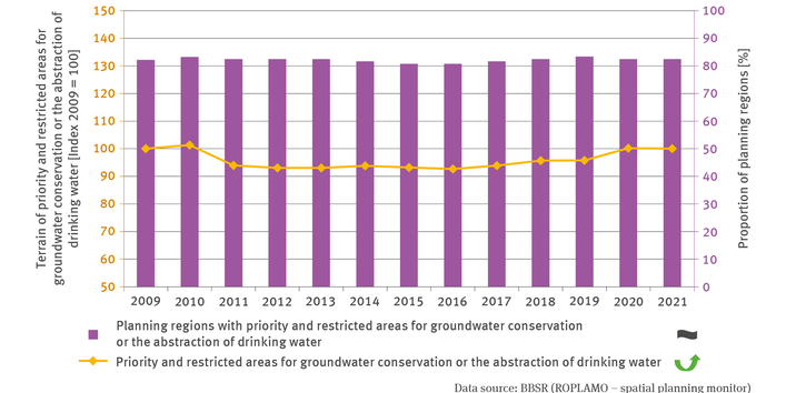
Planning at Länder and regional level can designate priority and restricted areas for the conservation of drinking water and groundwater, thus safeguarding water resources by means of planning processes, moderating between conflicting claims on land use and avoiding or mitigating conflicts. Just under 80 % of planning regions make use of this option. The high proportion of designating planning regions demonstrates that spatial planning tools are not just used in planning regions which tend to be affected by water shortages. In fact, the conservation and safeguarding of water resources is of major importance also in water-rich areas, to some extent because their water resources are in part used for provisioning water-poor areas.
To what extent various area categories are implemented for the conservation of groundwater and drinking water in individual planning regions depends above all – apart from variations in planning practice – on the individual spatial properties of regions, such as soil properties and geological baseline conditions, for instance whether the vegetation is near-natural and the intensity of its exploitation. In 2021 an overall terrain of more than 41,500 square kilometres in Germany was designated as priority or restricted areas for the conservation of drinking water and groundwater – the equivalent of more than 10 % of the total land area of the Federal Republic. Even though the areal expanse alone does not facilitate any direct conclusions on whether areas are designated to the appropriate spatial extent or quality, this percentage does illustrate the great importance attached to the conservation of water resources by spatial planning.
As a rule, regional plans are newly drawn up or updated every 10 to 15 years. In this process, planning regions may update the specifications contained in plans, which may entail changes in areal designations. Furthermore, plans may on these occasions also be adapted to changes in law or jurisdiction. Nationwide, the terrain designated in planning terms for the conservation of water resources initially decreased after 2010. However, beginning in 2017, this development has reversed so that the expanse of designated terrain has been increasing again. For example, the value originally recorded in 2009 was finally reached again in 2020 thanks to the new large-scale designation of priority areas reserved for groundwater and drinking water conservation incorporated in the regional plan for Saxony’s planning region of Oberes Elbtal-Osterzgebirge which came into force in 2020.
It is to be expected that owing to climate change the conservation of water resources will gain even greater significance in years to come. This background was one of the reasons why the Federal Cabinet adopted the National Water Strategy in March 2023. This strategy aims to achieve sustainable use of water resources by the middle of this century, in respect of both, human beings and the environment, ensuring the conservation and restoration of a near-natural water regime, and enhancing climate-adapted water infrastructures. This includes the use of planning processes to ensure the cooperation between the water management on one hand and spatial planning on the other, in order to safeguard terrain for groundwater recharge and the abstraction of drinking water, for instance by stipulating priority areas for future water abstraction areas in regional plans.221
Apart from the option to stipulate the designation of priority areas for future water supplies, as for instance by safeguarding future water conservation areas, it is important also to take into account the safeguarding of areas for groundwater recharge. Especially the latter objective includes certain requirement regarding the nature of the actual soil cover; this is because the areas thus safeguarded must allow for good infiltration of water into the soil. So far, spatial planning has provided limited opportunities in this respect, for instance the option, rarely used so far, to designate priority areas for expanding woodland cover. The increasingly frequent occurrence of drought periods suggests that the safeguarding and promotion of groundwater recharge might become an important task for spatial planning thus needing to be expanded accordingly.
221 - BMUV – Bundesministerium für Umwelt, Naturschutz, nukleare Sicherheit und Verbraucherschutz: Nationale Wasserstrategie. https://www.bmuv.de/wasserstrategie


