KM-I-6: Pumping station performance – case study
 Click to enlarge
Source: Rainer Knäpper / Free Art License (http://artlibre.org/licence/lal/en/)
2023 Monitoring Report on the German Strategy for Adaptation to Climate Change
Click to enlarge2023 Monitoring Report on the German Strategy for Adaptation to Climate Change
In order to keep, in particular, coastal lowland areas in agricultural production, artificial drainage including the use of pumping stations is an essential tool supplementary to drainage in free incline. Especially storm surges and floods which can occur more frequently owing to climate change, increase the need for drainage thus increasing electricity consumption by pumping stations in the area covered by the Eider Treene Association.
On the North German coast, the scenery of entire regions is characterised by lowland areas. The plains, some of which are quite extensive, are in part due to glacial erosion and formative processes at the end of the last glacial period, when the glaciers that had advanced into northern Germany, began to melt. Later on, the fertile plains were subject to cultural-historical influences. To this day the North German Plain continues to be subject to a wide and extremely varied spectrum of utilisation: Some of the lowland areas provide habitats for rare species of plants and animals which makes them of singular importance to nature conservation. Furthermore, there are settlements and trade and industry businesses scattered over some areas. In particular near the coast, tourism is becoming increasingly relevant. The major part of the North German Plain is currently used for agricultural production.
The low altitude of the landscape – in most cases amounting to just a few metres above the mean sea level – combined with a low gradient have a compelling impact on the water regime and the hydrological conditions in these lowland areas. In order to maintain or even improve the conditions required, especially for the agricultural use of some areas, it is often necessary to implement supplementary artificial drainage in places where a continuous drainage in free incline is not possible. Generally speaking, agricultural areas can tolerate long-term backwater residence times of maximum 14 days before serious damage ís to be expected. For the purpose of artificial drainage, technical structures such as sluices with storage basins or pumping stations are used. In the latter case, the water is raised to a higher level thus allowing it to flow into a watercourse or the sea.
The lowland areas and the operation of equipment for artificial drainage are affected directly by the impacts of climate change. For northern Germany, an increase in winter precipitation and heavy-rain events in summer are to be expected. This development increases the hazards of flooding. At the same time, the rising sea level makes it difficult to direct the flow of water into the North Sea or the Baltic Sea. More frequent and more extensive storm surges can cause an additional increase in drainage requirements. The more frequent operation of pumping stations entails increases in electricity consumption. Moreover, operating costs rise when machinery is operated for longer periods or more frequently thus increasing wear as well as maintenance frequency.In Schleswig-Holstein almost a quarter of the entire terrain is below 2.5 metres above sea level, thus belonging to the category of lowland areas. Most of this land is located on the North Sea coast in the areas of Elbmarschen (Elbe marshland). Dithmarschen, Eiderstedt and Nordfriesland as well as the riparian areas of Eider, Treene and Sorge. Notably, half of these lowland areas are already being drained with the aid of pumping stations. Their operation is in the remit of some 500 water- and soil-related associations in the country. These are part of main associations which include members such as the Eider Treene Association. Extending to roughly 113,000 ha, this is the largest terrain covered by any dyke-and-sluice association in Schleswig-Holstein. Approximately 50,000 ha of the catchment area are categorised as lowlands. The situation prevailing in the Eider Treene Association is used as an example for this theme illustrated in the case-study indicator.
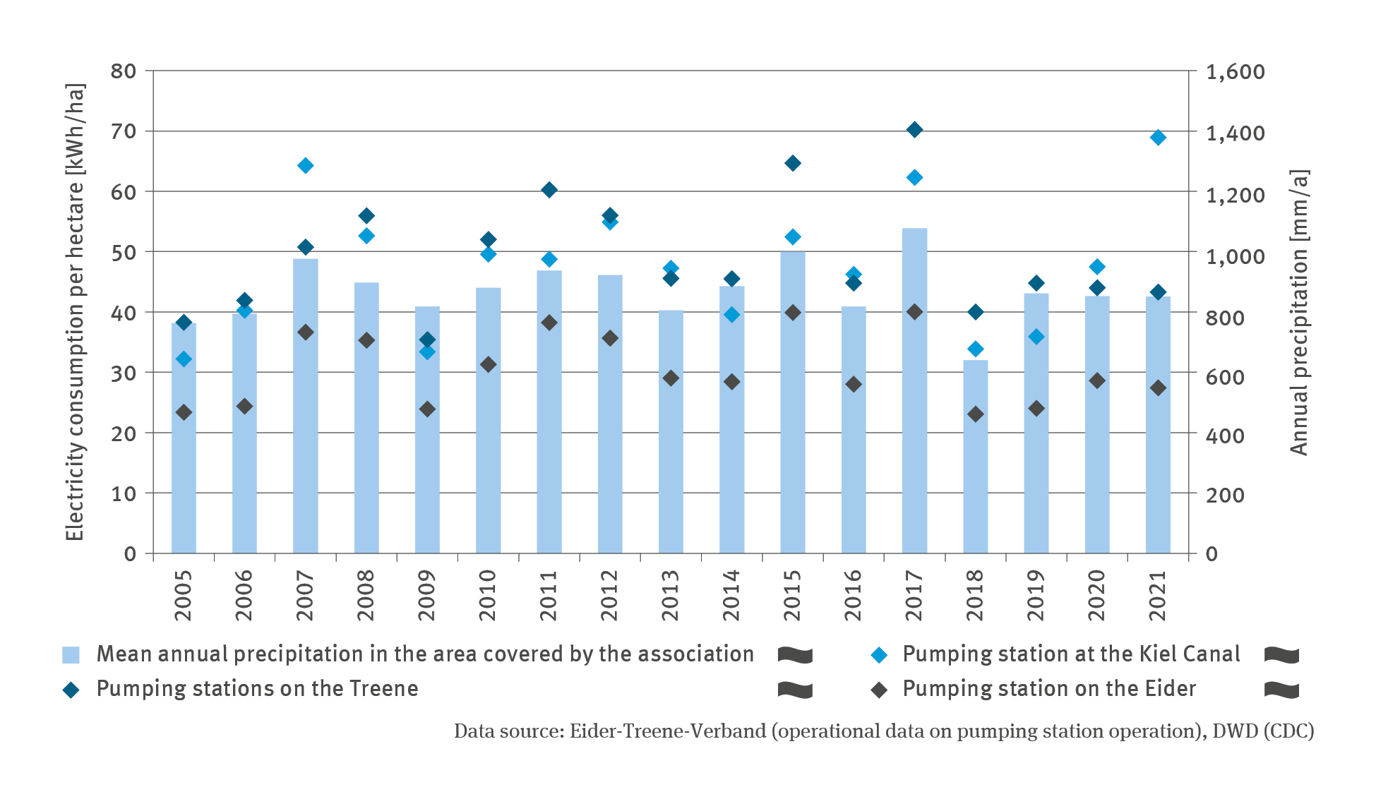
The indicator shows the annual electricity consumption of selected pumping stations within the terrain covered by the association, in hectares. In addition, the annual mean precipitation of the entire terrain covered by the association is illustrated. This is because the need for drainage in this area is essentially dependent on the precipitation scenario. The data demonstrate that the pumping stations used the greatest amount of electricity in the years with higher precipitation: In 2007 the pumping stations operating in the area of the Kiel Canal were consuming electricity at a rate of roughly 64 kWh / ha. The summer of 2007 produced a particularly high amount of precipitation, especially in northern Germany. In 2017, the utilisation of the pumping station in the areas of the rivers Eider and Treene respectively rose to its highest value. This was also the year in which the greatest amount of precipitation fell since 2005 for the area covered by the association. There is no significant trend for any of the time series.
However, the energy required by the pumps is not solely dependent on the duration of its operation and the hydrological requirements. The water- and soil-related associations endeavour to operate the most energy-efficient pumps. Technical improvements aimed at increasing energy efficiency can influence the progress illustrated by the indicator. Furthermore, the associations take every chance to reduce the cost of using the electricity network in an atypical way. For example, pumping takes place ‘in advance’ at times when the electricity cost is lower, regardless whether at that particular moment there is a hydrological requirement for operating the pumps. The water level of the watercourse on its way to the river mouth is another factor that influences the operation of the pumping station: If the water level rises too much in this watercourse, for instance, as a result of a heavy-rain event, the watercourse is unable to carry the pumped water away. In order to prevent recirculation of the water, the pump operation is ceased. In almost half of the pumping stations located in the Eider Treene area, pump operations are stopped at the time of flooding.
Owing to these circumstances, the interpretation of data on electricity consumption with regard to climate change is subject to restrictions. Many factors of influence interact in complex ways. Moreover, it has to be borne in mind that the situation regarding the relevant remits among the pumping station associations can vary substantially. Some terrains covered by associations are already now influenced more strongly by sea level rise. Against this background there is work in progress on developing the indicator further. These issues are highly relevant to the pumping station associations and agricultural businesses in the lowland areas. For the future it is to be expected that the existing drainage structures will come up against (economic) limitations. The intensification and expansion of pumping station operations will be inevitable in order to maintain the current utilisation of agricultural areas as well as the existing infrastructures.
The UBA’s motto, For our environment (“Für Mensch und Umwelt”), sums up our mission pretty well, we feel. In this video we give an insight into our work.
Due to the large number of enquiries, there may be delays in responding. We ask for your understanding.
