KM-I-4: Coastal morphology – case study
 Click to enlarge
Source: fotografci / stock.adobe.com
2023 Monitoring Report on the German Strategy for Adaptation to Climate Change
Click to enlarge2023 Monitoring Report on the German Strategy for Adaptation to Climate Change
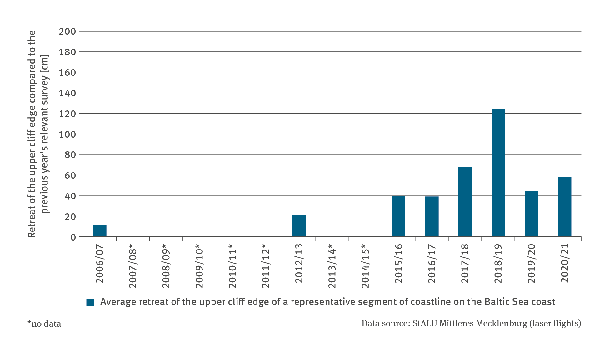
Climate change influences hydrodynamic factors that can affect coastal erosion. Data from aerial laser surveys of a representative segment of the cliffscape on the peninsula of Fischland on the Baltic Sea coast have every year been showing evidence of a further ‘retreat’ of the upper cliff edge. In particular, years with severe storm surges lead to substantial amounts of material breaking off.
Coastlines delineate a natural border between sea and mainland thus continuously exposing coasts to the force of the water. The interplay of erosion, transport and cumulative processes subjects them to continual change: The sediment removed from many parts of beaches or cliffs, once deposited elsewhere, can become new terrain. The nature of individual coastal segments and the way they are shaped, depend on their geomorphological properties, especially on the solidity of the rock concerned. Likewise of crucial importance are hydrodynamic factors such as sea currents, the tides, the water level and the state of the sea, but also heavy-rain events.
These factors of influence are the reason why coastal morphological changes are closely bound up with the impacts of climate change. As sea levels rise, the loads affecting coastlines increase. Storm surges will increase in height (cf. Indicator KM-I-3) and the waves are able to reach new areas available for attack. Extreme weather events such as heavy rain or frequently alternating frost and thaw periods can favour the erosion of cliffscapes. Given the multi-faceted functionality of coastal landscapes, their erosion or displacement are of major impact. The coast is a habitat for numerous, in some cases rare, animal and plant species. In addition to its ecological value, the coast is an important factor in the country’s economy owing to its high leisure and recreation value. Many adjacent communities are tourism-oriented. Combined with the high intensity of utilisation, the climatic changes exert increasing pressure on coastal areas and, in the absence of counter-measures, increase the ecological and economic risks confronting these areas.
The German coastline along the Baltic Sea is one of the areas where beaches shrink and cliff edges keep receding further inland. It is a characteristic feature of the coastline that steep and shallow shores alternate, where especially certain types of sand and loose materials are eroded. It is uncertain how much material has actually been eroded. So far there are no continuous or contiguous data available on the material decline of German coastlines. Owing to the complexity of erosion processes, data collection is requires major technical effort and is subject to inaccuracies.In order to gain insights on the erosion-related decline of the German Baltic Sea coast and defying these adversities, the Staatliche Amt für Landwirtschaft und Umwelt Mittleres Mecklenburg (StALU), has been conducting laser flight surveys on the coast of Mecklenburg-Western Pomerania on an annual basis. Every autumn, the representative segment of cliffscape between the municipalities of Wustrow and Ahrenshoop is subjected to measuring surveys over a distance of roughly three kilometres. Data on the location of the upper cliff edge are used to determine the average annual retreat of the coastline. The survey data were used to underpin the case-study indicator presented in this report. Like most of the coastlines marked by cliffscapes in Mecklenburg-Western Pomerania, this coastal segment too is subject to natural dynamics, characterised by the fact that eroded material from these cliffscapes is deposited in parallel with the coastline thus benefiting shallow sections of the coast occupied by settlements.
The erosion proceeding at this cliffscape is subject to a cyclical pattern. First, the offshore part of the cliff face – an accumulation of sediments already fallen off the cliff face – is eroded during a storm surge. As further material is removed from the bottom of the cliff, a cavity is created. The resulting overhang and the instability of the cliff – often combined with heavy-rain events – lead to rockfalls and material sliding down thus reshaping the foot of the cliff. Within the framework of these continuous processes, the cliffscapes in the coastal segment observed shift further inland by an average of 20 to 40 cm annually. In cases where extreme conditions, such as storm surges, prevail causing erosion processes to accelerate and intensify, the relocation of the upper cliff edge proceeds more rapidly increasing the distance by which the cliff edge ‘retreats’ inland.
The data examined in the case study underline the influence of storm surges on coastal decline: During the periods of 2017 / 2018 and 2018 / 2019 storm surges (some of them severe), caused partly severe erosion on the Fischland-Hochufer shore. In the autumn of 2018, east winds combined with major water volumes in the Baltic Sea, caused sea levels to rise on the coast. At the beginning of 2019, strong winds gave rise to two storm surge events in quick succession. In 2018 / 2019, the upper cliff edge on Fischland – compared to the survey findings of the previous year – retreated on average by more than 1.2 metres inland. In the interval between aerial surveys carried out in 2020 and 2021, the upper cliff edge had shifted inland by just under 60 cm. Given the brevity of the time series and the years when no aerial surveys took place, it was not possible to carry out a statistical trend analysis of the time series concerned.
The data provide insights into the erosion of a selected cliffscape segment on the coast of the Baltic Sea. As far as the coastal decline of other types of North Sea coasts is concerned, it would be either impossible or at least subject to major restrictions to draw any inferences from the findings above. Also with regard to the conditions prevailing on Fischland, these data can only be regarded as approximations. Given the distance of aircraft from the ground and for technical reasons, aerial laser surveys should not be regarded as accurate. Moreover, the length of the segment of coastline surveyed varies every year by some metres. Consequently, it is likely that more or less strongly eroding areas of coast at either end of the coastal segment surveyed are potentially not captured every year. Moreover, the intervals between years are not necessarily equal in duration.: Although the aerial surveys are always carried out in the same season, the dates of the actual flights tend to vary.
Despite these restrictions, the case study is able – thanks to any anthropogenic influences on Fischland being of a minor extent – to provide an impression of the naturally and climatically influenced erosion processes. Elsewhere counter-measures such as beach nourishments and groynes are used effectively to ward off erosion and shifts in the coastline. In the sandy, receded coasts of Mecklenburg-Western Pomerania, dunes combined with groynes are the most important elements employed in the coastal protection strategy (cf. Indicator KM-R-1).
The UBA’s motto, For our environment (“Für Mensch und Umwelt”), sums up our mission pretty well, we feel. In this video we give an insight into our work.
Due to the large number of enquiries, there may be delays in responding. We ask for your understanding.
